

ShipAtlas by Maritime Optima
Category : ProductivityVersion: 5.0.0
Size:156.09MOS : Android 5.1 or later
 Download
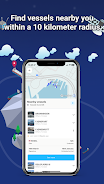
 ShipAtlas, by Maritime Optima, is the ultimate vessel tracking app for maritime enthusiasts and professionals alike. Leveraging real-time AIS data from over 700 satellites and terrestrial sources, ShipAtlas provides unparalleled insight into global maritime activities. Track vessels, analyze trade patterns, monitor port activities, and visualize sea routes with precision. Gain critical information on marine weather, ice conditions, and piracy zones, all overlaid on detailed marine maps. The app processes raw AIS data every second from the global merchant fleet, ensuring the highest quality and accuracy. Search for specific vessels using name, IMO, or MMSI numbers, or refine your search using details like LOA, beam, draft, and year built. Calculate sea routes with ease, receiving estimated time of arrival, distance, time at sea, and even estimated bunker consumption. Create and manage unlimited vessel lists for customized real-time tracking. Enjoy a user-friendly interface, seamless data synchronization across devices, and dedicated support via chat.
Features of ShipAtlas by Maritime Optima:
Comprehensive Maritime Intelligence: Access real-time data on port activities, sea routes, marine weather, ice conditions, piracy zones, and detailed marine maps.
High-Quality, Reliable Data: Benefit from rigorously processed and cleaned AIS data, ensuring accuracy and reliability for informed decision-making.
Powerful Vessel Search: Quickly locate vessels using name, IMO, MMSI number, or port details. Refine searches using vessel specifications like LOA, beam, draft, and year built.
Sea Route Optimization: Utilize the integrated sea route calculator to estimate time of arrival, distance, time at sea, and fuel consumption for efficient route planning.
Customizable Tracking & Lists: Create and manage unlimited vessel lists based on your specific needs and track their movements in real-time on the interactive map.
Conclusion:
ShipAtlas by Maritime Optima offers a user-friendly platform for accessing real-time AIS data and comprehensive maritime information. Its high-quality data, intuitive interface, and powerful features like the sea route calculator make it an invaluable tool for anyone involved in or interested in vessel tracking. While many features are available for free, upgrading to a paid subscription unlocks enhanced capabilities. Download ShipAtlas today and unlock a world of maritime insights. Learn more on our website.


Great app for tracking vessels in real-time! The AIS data is super accurate, and the interface is easy to navigate. Perfect for maritime pros and enthusiasts. Could use more offline features, though.


- Play Jetpack Joyride Racing on PC via BlueStacks 3 days ago
- Mass Test for New Battlefield Features 5 days ago
- Crashlands 2 Mobile Release Date Announced 1 weeks ago
- "Earthblade Cancelled: Celeste Devs Cite Disagreements" 1 weeks ago
- Mahershala Ali Awaits Marvel's Blade Revival 1 weeks ago
- Miku Joins Toram Online with Exclusive Outfits 2 weeks ago
- Ex-Nintendo Devs Praise 'Celestial' Game-Making Peers 2 weeks ago
- Nintendo to Host Donkey Kong Direct This Week 2 weeks ago
- Fallout Season 2 Leak Teases New Vegas Dinosaur 2 weeks ago
-

Lifestyle / 24.4.1 / by Calisteniapp, S.L. / 69.34M
Download -

Productivity / v1.0 / by xifa console / 2.95M
Download -

Lifestyle / 0.105 / by Veicoli Srl / 4.80M
Download -

Personalization / 1.3.2 / 229.15M
Download -

Tools / 2.2.8 / by Gspace Team / 15 MB
Download -

Personalization / v5.3.0 / by Free Action Games Lab / 93.63M
Download


-
 The 10 Best Teams in Marvel Strike Force (2025)
-
 Square Enix Creates New Policy To Protect Employees From Toxic Fans
-
 Celebrate 7th Anniversary: Solve the Mystery in Harry Potter: Hogwarts Mystery!
-
 How To Fix Marvel Rivals Compiling Shaders Slow on Launch
-
 It seems we can forget about explicit sex scenes in inZOI
-
 "ESO Expansions & DLC: Complete Order Guide"